Benefits of Our Services
The One-Call System will not mark private or non-member utilities. The utility locating companies notified by your state One-Call system will locate and mark only primary public utilities, so it's up to you to keep track of what else is on your property or that of your client.
Again, this is one of the areas where we can help.
Private Utilities are the buried lines after the meter or main lines. If you have a curbside meter then your property will not get marked by One-Call locators. Other buried utilities that generally are not marked by One-Call include but are not limited to: sewer lines, private lighting, sprinklers, fire mains, secondary electric lines to detached garages, and septic lines.
Construction Professionals & Home Owners Need GPR For:
* Utility detection - metallic and non-metallic
* Utility positioning
* Utility depth
* Damage prevention
* Void location
With our high-resolution antennas, even small subsurface targets are located in real-time and can be seen at depths ranging to 18 feet or more through natural or manmade surfaces. Unlike radio frequency locaters, GPR produces an image that displays the exact location and depth of both metallic and non-metallic subsurface utilities. GPR images can even be viewed in 3D. The technology is successful in a variety of difficult applications, such as the location of plastic and terracotta pipelines, water and sewer lines, cable, voids, tree roots and underground storage tanks.
Utilities are marked in the field using biodegradable pavement paint and/or flagging.
How GPR Works
The advantages of GPR are simple. As opposed to other locating techniques that are capable of detecting only metallic or conductive utilities and underground targets, GPR can locate and characterize both metallic and non-metallic subsurface features. It is completely non-intrusive, non-destructive and safe. GPR can be thought of as a Subsurface Imaging System, similar to sonar used for underwater applications. With GPR, surface conditions are not a major factor. Targets can be "seen" beneath reinforced concrete, asphalt, gravel, and most other common surfaces.
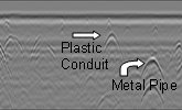
Actual data display of buried utilities above.
Some specific applications include the detection of underground storage tanks (USTs), utility locating, near-surface rock and water tables, the extent and boundaries of landfills, historic fill, detection of historic features, such as foundations, trash pits, and burials; grave site investigations, concrete structural analysis,floor/wall thicknesses, sub-base settlement and void detection; as well as nearly any other near-surface subsurface anomaly or target-of-concern.
GPR works by emitting a series of FCC-approved high-frequency, high-amplitude electromagnetic pulses (radio waves) that reflect off of underground irregularities. The resulting digital GPR data is fed into a portable video display which providesa real-time “picture” of a slice of the subsurface area. X-Zach GPR Services uses this picture to pinpoint the precise location of subsurface features on the ground surface in real time.
Some limiting factors in using GPR include site accessibility and penetration depths. While the GPR units are the size of laptops or smaller, the antenna systems can be fairly large. For an area to be surveyed with GPR, it must be relatively free from underbrush, debris and equipment. If you want an area surveyed, it has to be clear enough that you could push a shopping cart through it. The second limiting factor is depth of signal penetration. GPR should be thought of as a near-surface technique. For most commercial or industrial project sites, the realistic depth of signal penetration of GPR within the panhandle is usually 8' to 15' below the surface. Depths are totally dependent upon the GPR antenna system used and the properties of the subsoil. However, for the majority of projects, these depth ranges are more than sufficient to delineate most utilities, tanks, foundations, and other features-of-concern.
Click the links at the top of the page for more information.
